Tropical Depression 28, which is expected to become Tropical Storm or Hurricane Zeta early next week, has a path that would take it to the oft-struck central Gulf Coast next Thursday morning. The storm system is still so far away that forecasters indicate it could hit west into Texas or east in the Florida Panhandle. At this time, it looks like Mother Nature is pitching the ball right over home plate -- again. {AccuiWeather map}
Would-be Zeta is taking familiar path in the Gulf
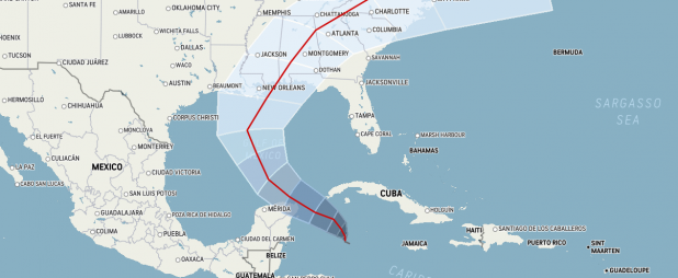
Tropical Depression 28 was west of Jamaica, southwest of Cuba and southeast of Cozumel today, moving north-northwast at 2 mph on a course that could send the season's 28th named storm into the Gulf Coast early next Thursday morning (Oct. 29).
If the storm system follows forecasters' prediction, it will become Tropical Storm Zeta Monday morning and pass by the storm-beleaguered Yucatan Tuesday and then be pulled toward the Gulf Coast by a cold front coming in from the north.
Current project indicate it could strengthen to a hurricane at some point during its path, but should be no more than a tropical storm when it makes landfall.
At this time projections put the possible arrival point anywhere from east Texas to the Florida Panhandle, but one usually reliable online forecast has it coming in southeast of New Orleans.
Sound familiar?
Louisiana has been hit by Cristobal, Laura, Marco, Beta and Delta so far this record-breaking hurricane season. Sally was expected to hit near New Orleans as well, but moved east to make landfall in Pensacola.
There have been 10 landfalls in the U.S., breaking the record of nine set in 1916. Would-be Zeta would be No. 11 if it earns its name.
The only other Zeta since Atlantic-Gulf storms have been given names was in late December 2005-early January 2006. This is only the second year that all 21 human names for storms were used and the Greek alphabet had to be used as a backup.
After Zeta is used, the next storm -- if there is one -- would be Eta. Hurricane season 2005 had 27 named storms and an unnamed subtropical storm that was idenitified after the season ended. That storm is considered to give 2005 28 storms. This season would tie that record if Zeta forms and there is an Eta in November.
There is a tropical system causing heavy rains in the Caribbean near the Bahamas, but forecasters do not give it much chance of reaching tropical storm status.
Meanwhile, Hurricane Epsilon is turning east into the Atlantic and will weaken to a tropical depression by early next week when it may take a northward route and break up before it reaches Iceland.
Epsilon rapidly strengthened to become a major Category 3 hurricane, but passed a few hundred miles east of Bermuda -- still close enough put the island under tropical storm warning and let the Bermudans know they had a near miss, after being hit by Hurricane Paulette and narrowly missed by Hurricane Teddy earlier this season.
Avoyelles Today will monitor the Gulf storm over the next few days and provide updates on its path, strength and expected point and date of arrival.