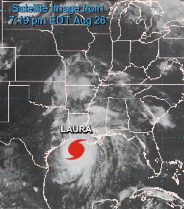
8pm update on Hurricane Laura
The eye of category 4 Hurricane Laura is 95 miles from Lake Charles and 95 miles from Port Arthur. It is moving north-northwest at 15 mph. Maximum winds are 150 mph, just below category 5 strength.
Tropical storm force winds are now approaching the I-10 corridor in Louisiana. Hurricane force winds will begin near the coast in the next 2 to 4 hours.
One large rain band is moving into the I-10 corridor now, and very heavy rain will be moving onshore over the next several hours.
Roger
Roger Erickson
Warning Coordination Meteorologist
National Weather Service
Lake Charles, LA
Tropical Storm Warning
Laura Local Watch/Warning Statement/Intermediate Advisory Number 28A
National Weather Service Lake Charles LA AL132020
700 PM CDT Wed Aug 26 2020
/
Avoyelles-
700 PM CDT Wed Aug 26 2020
...TROPICAL STORM WARNING REMAINS IN EFFECT...
* LOCATIONS AFFECTED
- Marksville
- Bunkie
- Simmesport
* WIND
- LATEST LOCAL FORECAST: Equivalent Tropical Storm force wind
- Peak Wind Forecast: 30-40 mph with gusts to 50 mph
- THREAT TO LIFE AND PROPERTY THAT INCLUDES TYPICAL FORECAST
UNCERTAINTY IN TRACK, SIZE AND INTENSITY: Potential for wind 58 to 73 mph
- The wind threat has remained nearly steady from the previous assessment.
- PLAN: Plan for dangerous wind of equivalent strong tropical storm force.
- PREPARE: Remaining efforts to protect life and property should be completed as soon as possible. Prepare for significant wind damage.
- ACT: Move to safe shelter before the wind becomes hazardous.
- POTENTIAL IMPACTS: Significant
- Some damage to roofing and siding materials, along with
damage to porches, awnings, carports, and sheds. A few
buildings experiencing window, door, and garage door
failures. Mobile homes damaged, especially if unanchored.
Unsecured lightweight objects become dangerous projectiles.
- Several large trees snapped or uprooted, but with greater
numbers in places where trees are shallow rooted. Several
fences and roadway signs blown over.
- Some roads impassable from large debris, and more within
urban or heavily wooded places. A few bridges and access
routes impassable.
- Scattered power and communications outages, but more
prevalent in areas with above ground lines.
* FLOODING RAIN
- LATEST LOCAL FORECAST: Flash Flood Watch is in effect
- Peak Rainfall Amounts: Additional 2-4 inches, with locally
higher amounts
- THREAT TO LIFE AND PROPERTY THAT INCLUDES TYPICAL FORECAST
UNCERTAINTY IN TRACK, SIZE AND INTENSITY: Potential for
moderate flooding rain
- The flooding rain threat has remained nearly steady from
the previous assessment.
- PLAN: Emergency plans should include the potential for
moderate flooding from heavy rain. Evacuations and rescues
are possible.
- PREPARE: Consider protective actions if you are in an area
vulnerable to flooding.
- ACT: Heed any flood watches and warnings. Failure to take
action may result in serious injury or loss of life.
- POTENTIAL IMPACTS: Significant
- Moderate rainfall flooding may prompt several evacuations
and rescues.
- Rivers and tributaries may quickly become swollen with
swifter currents and overspill their banks in a few places,
especially in usually vulnerable spots. Small streams,
creeks, canals, and ditches overflow.
- Flood waters can enter some structures or weaken
foundations. Several places may experience expanded areas
of rapid inundation at underpasses, low-lying spots, and
poor drainage areas. Some streets and parking lots take on
moving water as storm drains and retention ponds overflow.
Driving conditions become hazardous. Some road and bridge
closures.
* TORNADO
- LATEST LOCAL FORECAST: Tornado Watch is in effect
- Situation is favorable for tornadoes
- THREAT TO LIFE AND PROPERTY THAT INCLUDES TYPICAL FORECAST
UNCERTAINTY IN TRACK, SIZE AND INTENSITY: Potential for several
tornadoes
- The tornado threat has remained nearly steady from the
previous assessment.
- PLAN: Emergency plans should include the potential for
several tornadoes with a few possibly intense having larger
damage paths.
- PREPARE: Those living in manufactured homes or on boats are
urged to relocate to safe shelter before hazardous weather
arrives.
- ACT: Listen for tornado watches and warnings. If a tornado
warning is issued, be ready to shelter quickly.
- POTENTIAL IMPACTS: Significant
- The occurrence of scattered tornadoes can hinder the
execution of emergency plans during tropical events.
- Several places may experience tornado damage with a few
spots of considerable damage, power loss, and
communications failures.
- Locations could realize roofs torn off frame houses, mobile
homes demolished, boxcars overturned, large trees snapped
or uprooted, vehicles tumbled, and small boats tossed
about. Dangerous projectiles can add to the toll.
Hurricane Local Statement
Hurricane Laura Local Statement Intermediate Advisory Number 28A
Hurricane Laura Local Statement Intermediate Advisory Number 28A
National Weather Service Lake Charles LA AL132020
719 PM CDT Wed Aug 26 2020
Below info covers Southwest Louisiana and Southeast Texas
**WINDS INCREASING AS EXTREMELY DANGEROUS HURRICANE LAURA TAKES AIM AT THE
NORTHWEST GULF COAST**
**CATASTROPHIC STORM SURGE, EXTREME WINDS, AND FLASH FLOODING EXPECTED
ALONG THE NORTHWEST GULF COAST TONIGHT**
NEW INFORMATION
---------------
* CHANGES TO WATCHES AND WARNINGS:
- None
* CURRENT WATCHES AND WARNINGS:
- A Storm Surge Warning and Hurricane Warning are in effect for
Acadia, Calcasieu, East Cameron, Jefferson, Jefferson Davis,
Orange, Vermilion, and West Cameron
- A Hurricane Warning is in effect for Allen, Beauregard,
Evangeline, Hardin, Northern Jasper, Northern Newton, Rapides,
Southern Jasper, Southern Newton, Tyler, and Vernon
- A Storm Surge Warning, Tropical Storm Warning, and Hurricane
Watch are in effect for Iberia, Lower St. Martin, and St. Mary
- A Tropical Storm Warning is in effect for Avoyelles, Lafayette,
St. Landry, and Upper St. Martin
* STORM INFORMATION:
- About 100 miles south-southeast of Cameron LA or about 140
miles southwest of Morgan City LA
- 28.4N 92.9W
- Storm Intensity 150 mph
- Movement North-northwest or 330 degrees at 15 mph
SITUATION OVERVIEW
------------------
At 700 PM CDT (0000 UTC), the center of Hurricane Laura was located
near latitude 28.4 North, longitude 92.9 West. Laura is moving toward
the north-northwest near 15 mph (24 km/h) and a turn toward the
north is expected overnight, and a northward motion should continue
on Thursday. On the forecast track, Laura will approach the upper
Texas and southwest Louisiana coasts this evening and move inland
within that area tonight.
Laura is an extremely dangerous category 4 hurricane with maximum
sustained winds of 150 mph. Laura will arrive as a major category 4
hurricane at landfall overnight. Maximum storm surge values will be
expected between 15 to 20 feet above ground level for portions of the
coastal sections of southwest Louisiana. This will result in life
threatening inundation. Evacuate immediately if you are within an area
where this extreme surge may occur. Also a significant surge will occur
up the lower Neches, Sabine, Calcasieu, Mermentau, and Vermilion River
basins.
Heavy rain producing bands of showers and isolated thunderstorms will
continue to move inland across the Louisiana coastline this evening as
Laura continues its northwest approach, then expand northward
overnight as Laura moves inland. A moderate to high risk of flash
flooding will result. Isolated to several tornadoes will also be
possible across the area.
Tropical storm force winds are expected to continue to spread across
southwest Louisiana this evening and southeast Texas later tonight.
Hurricane force winds, especially in frequent gusts, will be likely
beginning late tonight across southwest Louisiana and southeast Texas
continuing into Thursday morning up into upper southeast Texas and west
central Louisiana.
POTENTIAL IMPACTS
-----------------
* WIND:
Potential impacts from the main wind event are now unfolding across
southwest Louisiana and southeast Texas. Remain well sheltered from
life-threatening wind having possible devastating impacts. If
realized, these impacts include:
- Structural damage to sturdy buildings, some with complete roof
and wall failures. Complete destruction of mobile homes. Damage
greatly accentuated by large airborne projectiles. Locations
may be uninhabitable for weeks or months.
- Numerous large trees snapped or uprooted along with fences and
roadway signs blown over.
- Many roads impassable from large debris, and more within urban
or heavily wooded places. Many bridges and access routes
impassable.
- Widespread power and communications outages.
* SURGE:
Potential impacts from the main surge event are now unfolding across
the lower southwest Louisiana coastline and southeast Texas coastline.
Remain well away from life-threatening surge having possible
catastrophic impacts. If realized, these impacts include:
- Widespread deep inundation, with storm surge flooding greatly
accentuated by powerful battering waves. Structural damage to
buildings, with many washing away. Damage greatly compounded
from considerable floating debris. Locations may be
uninhabitable for an extended period.
- Escape routes and secondary roads washed out or severely
flooded. Flood control systems and barriers may become stressed
or overtopped.
- Extreme beach erosion. New shoreline cuts possible.
- Massive damage to marinas, docks, and piers. Numerous small
craft broken away from moorings with many lifted onshore and
stranded.
* FLOODING RAIN:
Potential impacts from the flooding rain are still unfolding across
southwest Louisiana and southeast Texas. Remain well guarded against
life-threatening flood waters having possible devastating impacts. If
realized, these impacts include:
- Extreme rainfall flooding may prompt numerous evacuations and
rescues.
- Rivers and tributaries may overwhelmingly overflow their banks
in many places with deep moving water. Small streams, creeks,
canals, and ditches may become raging rivers. Flood control
systems and barriers may become stressed.
- Flood waters can enter numerous structures within multiple
communities, some structures becoming uninhabitable or washed
away. Numerous places where flood waters may cover escape
routes. Streets and parking lots become rivers of raging water
with underpasses submerged. Driving conditions become very
dangerous. Numerous road and bridge closures with some weakened
or washed out.
* TORNADOES:
Potential impacts from tornadoes are still unfolding across southwest
Louisiana and southeast Texas. Remain well braced against a dangerous
tornado event having possible significant impacts. If realized, these
impacts include:
- The occurrence of scattered tornadoes can hinder the execution
of emergency plans during tropical events.
- Several places may experience tornado damage with a few spots
of considerable damage, power loss, and communications failures.
- Locations could realize roofs torn off frame houses, mobile
homes demolished, boxcars overturned, large trees snapped or
uprooted, vehicles tumbled, and small boats tossed about.
Dangerous projectiles can add to the toll.
PRECAUTIONARY/PREPAREDNESS ACTIONS
----------------------------------
* EVACUATIONS:
Do not enter evacuated areas until officials have given the all clear
to return.
* OTHER PREPAREDNESS INFORMATION:
Now is the time to stay inside and away from windows. Listen for
updates and be ready in case you lose electrical power. Keep a battery-
powered radio, charged cell phone and flashlight handy.
During the peak of the storm be ready to move quickly. Keep your
shoes on and rain gear handy. Boots and athletic shoes offer the best
foot protection if you become unexpectedly exposed to the weather.
Keep your cell phone charged and in power-saving mode. If you lose
power, use it sparingly and mainly for personal emergencies and
check-ins.
Do not venture outside while in the eye of a hurricane as any
improvement in weather will only be temporary. Once the eye passes,
conditions will become life threatening as winds immediately return
to dangerous speeds, so remain safely sheltered from the storm.
Do not be a thrill seeker or risk your life for senseless photos or
videos.
Quickly move to the safest place within your shelter if it begins to
fail, preferably an interior room on the lowest floor as long as
flooding is not a concern.
If you are prone to flooding or in an area under a storm surge watch
or warning, be prepared for the possibility of a quick and dramatic
rise in water levels.
If a tornado warning is issued for your area, quickly move to the
safest place within your shelter. Protect your head and body.
If an Extreme Wind Warning is issued for your area, move to the
safest place within your shelter. Take the same life-saving actions
as if it were a violent tornado.
* ADDITIONAL SOURCES OF INFORMATION:
- For information on appropriate preparations see ready.gov
- For information on creating an emergency plan see getagameplan.org
- For additional disaster preparedness information see redcross.org
NEXT UPDATE
-----------
The next local statement will be issued by the National Weather
Service in Lake Charles LA around 11 PM CDT, or sooner if conditions
warrant.