Laura strengthens overnight
Below is the 6 am update from the National Weather Service on Hurricane Laura:
Hurricane Laura Local Statement Advisory Number 26
LAZ027>033-041>045-052>055-073-074-TXZ180-201-215-216-259>262-261800-
Hurricane Laura Local Statement Advisory Number 26
National Weather Service Lake Charles LA AL132020
449 AM CDT Wed Aug 26 2020
This product covers Southwest Louisiana and Southeast Texas
**Hurricane Laura continues to intensify and is expected to
strengthen to a dangerous major hurricane prior to landfall.**
NEW INFORMATION
---------------
* CHANGES TO WATCHES AND WARNINGS:
- None
* CURRENT WATCHES AND WARNINGS:
- A Storm Surge Warning and Hurricane Warning are in effect for
Acadia, Calcasieu, East Cameron, Jefferson, Jefferson Davis,
Orange, Vermilion, and West Cameron
- A Hurricane Warning is in effect for Allen, Beauregard,
Evangeline, Hardin, Northern Jasper, Northern Newton, Rapides,
Southern Jasper, Southern Newton, Tyler, and Vernon
- A Storm Surge Warning, Tropical Storm Warning, and Hurricane
Watch are in effect for Iberia, Lower St. Martin, and St. Mary
- A Tropical Storm Warning is in effect for Avoyelles, Lafayette,
St. Landry, and Upper St. Martin
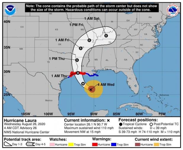
* STORM INFORMATION:
- About 300 miles south-southeast of Cameron LA or about 250
miles south of Morgan City LA
- 26.1N 90.7W
- Storm Intensity 110 mph
- Movement Northwest or 310 degrees at 15 mph
SITUATION OVERVIEW
------------------
At 400 AM CDT (0900 UTC), the center of Hurricane Laura was located
near latitude 26.1 North, longitude 90.7 West. Laura is moving
toward the northwest near 15 mph (24 km/h) and this general motion
should continue today, and a north-northwestward motion is forecast
tonight. On the forecast track, Laura should approach the Upper
Texas and southwest Louisiana coasts on this evening and move inland
near those areas tonight or Thursday morning.
Laura continues to intensify and will arrive as a major hurricane
tonight. Expected storm surge values have increased reaching a
maximum of 10 to 15 ft. This will result in life threatening
inundation. Evacuate immediately if you are within an area where
this extreme surge may occur. Also a significant surge will occur up
the lower Neches, Sabine, Calcasieu, Mermentau, and Vermilion River
basins.
Heavy rain producing bands of showers and a few thunderstorms will
begin to advance inland this afternoon as Laura continues its
northwest approach, then expand northward overnight as Laura moves
inland. A moderate to high risk of flash flooding will result.
Isolated tornadoes will also be possible across the area.
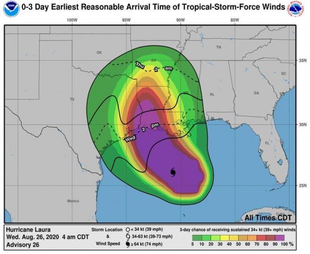
Tropical storm force winds are expected to spread across southwest
Louisiana this afternoon and southeast Texas this evening. Hurricane
force winds, especially in frequent gusts, will be likely beginning
Wednesday night across southwest Louisiana and southeast Texas
continuing into Thursday morning up into upper southeast Texas and
west central Louisiana.
POTENTIAL IMPACTS
-----------------
* SURGE:
Prepare for life-threatening surge having possible catastrophic
impacts across lower southwest Louisiana and southeast Texas.
Potential impacts in this area include:
- Widespread deep inundation, with storm surge flooding greatly
accentuated by powerful battering waves. Structural damage to
buildings, with many washing away. Damage greatly compounded
from considerable floating debris. Locations may be
uninhabitable for an extended period.
- Escape routes and secondary roads washed out or severely
flooded. Flood control systems and barriers may become stressed
or overtopped.
- Extreme beach erosion. New shoreline cuts possible.
- Massive damage to marinas, docks, and piers. Numerous small
craft broken away from moorings with many lifted onshore and
stranded.
* WIND:
Prepare for life-threatening wind having possible devastating impacts
across southeast Texas and southwest Louisiana. Potential impacts in
this area include:
- Structural damage to sturdy buildings, some with complete roof
and wall failures. Complete destruction of mobile homes. Damage
greatly accentuated by large airborne projectiles. Locations
may be uninhabitable for weeks or months.
- Numerous large trees snapped or uprooted along with fences and
roadway signs blown over.
- Many roads impassable from large debris, and more within urban
or heavily wooded places. Many bridges and access routes
impassable.
- Widespread power and communications outages.
* FLOODING RAIN:
Prepare for life-threatening rainfall flooding having possible
extensive impacts across southeast Texas and southwest Louisiana.
Potential impacts include:
- Major rainfall flooding may prompt many evacuations and rescues.
- Rivers and tributaries may rapidly overflow their banks in
multiple places. Small streams, creeks, canals, and ditches may
become dangerous rivers. Flood control systems and barriers may
become stressed.
- Flood waters can enter many structures within multiple
communities, some structures becoming uninhabitable or washed
away. Many places where flood waters may cover escape routes.
Streets and parking lots become rivers of moving water with
underpasses submerged. Driving conditions become dangerous.
Many road and bridge closures with some weakened or washed out.
* TORNADOES:
Prepare for a tornado event having possible limited across
Southwest Louisiana and Southeast Texas. Potential impacts include:
- The occurrence of isolated tornadoes can hinder the execution
of emergency plans during tropical events.
- A few places may experience tornado damage, along with power
and communications disruptions.
- Locations could realize roofs peeled off buildings, chimneys
toppled, mobile homes pushed off foundations or overturned,
large tree tops and branches snapped off, shallow-rooted trees
knocked over, moving vehicles blown off roads, and small boats
pulled from moorings.
PRECAUTIONARY/PREPAREDNESS ACTIONS
----------------------------------
* EVACUATIONS:
Listen to local official for recommended preparedness actions,
including possible evacuation. If ordered to evacuate, do so
immediately.
For those not under evacuation orders, assess
the risk from wind, falling trees, and flooding at your location. If
you decide to move, relocate to a safer location nearby. If you do
not relocate, help keep roadways open for those under evacuation
orders.
If evacuating, leave with a destination in mind
and allow extra time to get there. Take your emergency supplies kit.
Gas up your vehicle ahead of time.
Let others know where you are going prior to
departure. Secure loose items and pets in the car, and avoid
distracted driving.
If evacuating, follow designated evacuation
routes. Seek traffic information on roadway signs, the radio, and
from official sources.
*
* OTHER PREPAREDNESS INFORMATION:
Now is the time to check your emergency plan and emergency supplies
kit and take necessary actions to protect your family and secure your
home or business.
When making safety and preparedness decisions, do not focus on the
exact forecast track since hazards such as flooding rain, damaging
wind gusts, storm surge, and tornadoes extend well away from the
center of the storm.
If in a place that is vulnerable to high wind, such as near large trees, a manufactured home, upper floors of a high-rise building, or
on a boat, plan to move to safe shelter.
If you live in a place particularly vulnerable to flooding, such as
near the ocean or a large inland lake, in a low-lying or poor
drainage area, in a valley, or near an already swollen river, plan to
move to safe shelter on higher ground.
Always heed the advice of local officials and comply with orders that
are issued. Do not needlessly jeopardize your life or the lives of
others.
When securing your property, outside preparations should be concluded
as soon as possible before conditions deteriorate. The onset of
strong gusty winds or flooding can cause certain preparedness
activities to become unsafe.
Be sure to let friends and family members know of your intentions for
weathering the storm and your whereabouts. Have someone located away
from the threatened area serve as your point of contact. Share vital
contact information with others. Keep cell phones handy and charged.
Check on those who may not be fully aware of the situation or who are
unable to make personal preparations.
If you are a visitor, know the name of the county or parish in which
you are located and where it is relative to current watches and
warnings. If staying at a hotel, ask the management staff about their
onsite disaster plan. Listen for evacuation orders, especially
pertaining to area visitors.
Closely monitor weather.gov, NOAA Weather Radio and local news
outlets for official storm information. Listen for possible changes
to the forecast.
There is a threat from tornadoes with this storm. Have multiple ways
to receive Tornado Warnings. Be ready to shelter quickly.
*
* ADDITIONAL SOURCES OF INFORMATION:
- For information on appropriate preparations see ready.gov
- For information on creating an emergency plan see getagameplan.org
- For additional disaster preparedness information see redcross.org
NEXT UPDATE
-----------
The next local statement will be issued by the National Weather
Service in Lake Charles LA around 11 AM CDT, or sooner if conditions
warrant.
$$